Wednesday, October 29, 2014

More cave ruins

06 sep 2014

Flying from Blanding, Utah

This is the northern end of the Comb Ridge
which we saw from Bluff earlier.

 This is the Butler Wash ruins from the air.

 There's an easy walk to a view point,
but can't get right to the ruins.


 Looking south, that ridge has dozens of such ruins.
Must have been a large population living there
and growing their crops in the valley.
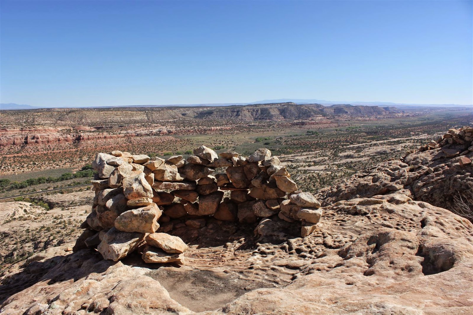
 There's a little spot on a rock on the top of the ridge.

I hiked up there, and found this stonework.
I think must have been a lookout point,
could spot any invaders moving in the valley.


Camped in the valley.

Moon rise over the rocks.....

Saturday, October 25, 2014

Spanish Peaks, southern Colorado.


12 Oct 2014

Spanish Peaks, southern Colorado.

It's even colder than it looks here.
Snow low on the mountains, about 9,000ft,
and a howling wind, so vicious wind chill....

I had perfect autumn weather for all of September and early October,
but now winter is coming,
so it's time to head south.....

Friday, October 24, 2014

Rio Grande canyon.

13 Oct 2014

Flying from Questa, northen New Mexico


 The Rio Grande canyon.
I first saw this river near Crede, CO.
Would like to follow it all the way to the Gulf of Mexico.

On Questa airfield.
Snow-capped mountains still too close....
Still windy, so the flight was cold, rough.....

Thursday, October 23, 2014

Ohkay Owingeh, New Mexico

14 Oct 2014

Flying from Ohkay Owingeh airfield, near Los Alamos, NM.


This photo is towards Los Alamos, but far away....
It's where the atom bomb was designed, and research still going on....
There's still a restricted zone overhead, so I'm not going any closer,
and don't want any better photos or I may get attention from Homeland Security....


The reason I came here to get a look into the Valle volcanic caldera.
That's the northern rim, but it's 11,000ft altitude....
There's a northerly breeze today, so I'm hoping to get some stable lift up that slope...

 The plan worked well, and I got up to 12,000 ft to get a look over the highest peak.
Still doesn't look like much, but the caldera is huge,
that's the southern rim far away....
But notice that this 11,000ft mountain has no snow,
so not so cold as yesterday....


This is the way they give each owner access to the river.
Actually they call these hobby farms 'ranches' here.....

Wednesday, October 22, 2014

Volcanic Necks

15 Oct 2014

I wanted to fly both the 'volcanic necks' and the Valle Caldera, but couldn't identify any airfield close enough....  So I just went near there and started looking for a road that would suit....  Finding suitable roads is really difficult, due to traffic, laws, and access that allows setup of the aircraft without disrupting traffic....  But this time I was really lucky.  Drove thro a lot of Indian land (private property) and found a suitable piece of road in BLM land (public land).  With a convenient place to pull off the road and set up the aircraft....

There was range cattle on the land, and next morning just as I was ready to go, two bulls started to fight nearby.....   They bellowed and torn up the ground, and I hoped they didn't tear up my aircraft, but they were so occupied that they didn't notice me, so I set up and easily took off from the road, and flew to the volcanic necks.


On the way to the 'volcanic necks', rugged and remote....

Glad to find this road on the left, after the remote and rugged terrain...


 I had expected the 'volcanic necks'  to be more slim and vertical,
but they're a lot like the 'Glasshouse Mountains' back home in Queensland...
as shown below, early morning....

More rock forms....

And more gulleys....


I tried to get to the Valle Caldera from this southern side,
but this narrow valley with only this narrow busy road for outlanding possibility,
was too much of a risk, so I turned back.....
Very disappointing and discouraging to have to turn back.....
So I'm not a bold pilot,
but I guess that's why I'm still an old pilot......
75 y.o. last month and I plan to keep on flying safely for some time to come...


Back on the ground safe and sound.....


Nearby was all these empty shell casings, and heaps more.

And this rubbish...

And this target practice....

There was gunfire nearby heard almost all the time that I was camped there.....
I don't mind the shooting, but please leave nothing behind on public land....
And some of these same people complain about 'loss of freedom' 
by being denied access to such public lands....
With freedom comes responsibility.


Tuesday, October 21, 2014

Craters, lava flows, I-40, Route 66, misc.

16 Oct 2014

Part of the reason I came to fly from Grants-Milan airfield
was for the volcanic activity nearby.
Just one of the cinder cones nearby.

The El Malpais lava flow
is enormous!


Typical truck traffic on the I-40 interstate highway.
Fine highways, carrying so much commerce so safely and easily....


 An abandoned gas station on the old Route 66.
Many travelers would have stopped there over the years....

An old mud-brick building along Route 66

Indians like colourful roofs on their houses.
Much brighter than the usual contemporary American style of 'earth' colours....

Here's one way to tell what the wind is at the surface....

Monday, October 20, 2014

The Concrete Arrows story

16 Oct 2014

Flying from Grants-Milan airfield, New Mexico.

Ever since I first heard about those concrete arrows for early trans-continental navigation, I've been interested in them.  I guess I first heard about them on the internet.  While still in Australia, I found out the locations of several of those remaining, and determined to fly over some of them.  I had found and flown over three near St George UT, one near Tooele UT, one near Wendover NV, and one near here.

When I got over here, I was surprised to find that very few American pilots had even heard of them.....  Then I finally struck lucky at Grants-Milan airfield in New Mexico.  They not only know of many such arrows, but are are establishing a museum about that form of navigation.  Steve is the driving force behind this museum, and shared a whole lot of knowledge with me.

It turns out that there was a lot more to the system than just the arrows.  That plaque near an arrow near St George, Utah, stated that there was just a kerosene light on the tower.  But this restored tower at the Grant-Milan museum shows what was really there.  There was a powerful rotating beacon, plus a 'lane' light beamed along the flight path.  All this was powered by a generator in the hut, controlled by a time switch and relays, making for a sophisticated automatic system for that time.  There were large fuel tanks, so the beacon could work unattended for weeks or even months at a time, especially in winter when some sites would be inaccessible.  Then a roving technician would make the rounds and service and fuel the beacons.  These beacons were spaced 10 miles apart, along the transcontinental air routes, so that made for a whole lot of beacons, about 1800 I'm told.  It was a giant undertaking that first made it possible to have trans-continental mail and passenger services, and should be be more recognized in aviation history.  In the 1930s radio navigation facilities took their place.

There's a good story of it all at:
http://sometimes-interesting.com/2013/12/04/concrete-arrows-and-the-u-s-airmail-beacon-system/#more-7727


The restored beacon at Grants-Milan airfield museum.
The 'LA-A' signifies the Los Angelese - Albuquerque airway.

This is the arrow near Casa Blanca, NM,
 that I had located on Google Maps while still in Australia,
and came to Grants-Milan to fly it.
#64 on the Los Angeles/Albuquerque route.
All the arrows that I found are pointing eastward....


I hiked up to the arrow for a better look.

Airliners are still flying the same route,
but I don't think they can see the arrow from up there.....

th

Friday, October 17, 2014

Ogallala Aquifer

20 Oct 2014

Flying from Muleshoe, Texas

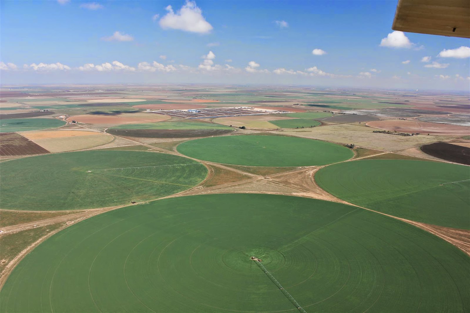
 This is extremely productive country,
irrigated from the Ogallala Aquifer.
http://en.wikipedia.org/wiki/Ogallala_Aquifer

With lots of water and sunshine and the long growing season,
and of course, Texas work ethic,
the amount of produce grown here is incredible!


The big grain handling facilities tell of the productivity.
There's enough grain stored here to feed millions of people, 


There's more grain stored in those white 'sausages'.
And two trains, both with double-stacked containers,
tell of the dynamic activity in this country....

Lots of the grain goes to cattle feed lots like this one,
and silage being hauled in by the multiple semi loads.

There's a whole bunch of Angus steaks down there getting fat.....


Always interesting patterns in this irrigated agriculture.
Cotton in foreground.


This dome is covering water storage for Lubbock city.
They also compete for Ogallala water....